


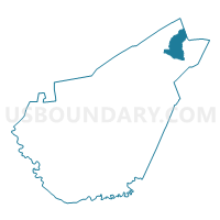
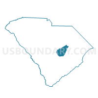
Hicks Voting District, Clarendon County, South Carolina
About
Outline

Summary
| Unique Area Identifier | 665499 |
| Name | Hicks Voting District |
| County | Clarendon County |
| State | South Carolina |
| Area (square miles) | 13.15 |
| Land Area (square miles) | 13.11 |
| Water Area (square miles) | 0.05 |
| % of Land Area | 99.65 |
| % of Water Area | 0.35 |
| Latitude of the Internal Point | 33.86796660 |
| Longtitude of the Internal Point | -79.98696330 |
Maps

Graphs
Select a template below for downloading or customizing gragh for Hicks Voting District, Clarendon County, South Carolina


Neighbors
Neighoring Voting District (by Name) Neighboring Voting District on the Map
- Barrineau Voting District, Clarendon County, SC
- New Zion Voting District, Clarendon County, SC
- Olanta Voting District, Florence County, SC
- Turbeville Voting District, Clarendon County, SC
Top 10 Neighboring County Subdivision (by Population) Neighboring County Subdivision on the Map
- Olanta CCD, Florence County, SC (3,879)
- Turbeville CCD, Clarendon County, SC (3,527)
- Sardinia CCD, Clarendon County, SC (3,281)
Top 10 Neighboring Place (by Population) Neighboring Place on the Map
Top 10 Neighboring Unified School District (by Population) Neighboring Unified School District on the Map
Top 10 Neighboring State Legislative District Lower Chamber (by Population) Neighboring State Legislative District Lower Chamber on the Map
Top 10 Neighboring State Legislative District Upper Chamber (by Population) Neighboring State Legislative District Upper Chamber on the Map
Top 10 Neighboring 111th Congressional District (by Population) Neighboring 111th Congressional District on the Map
Top 10 Neighboring Census Tract (by Population) Neighboring Census Tract on the Map
- Census Tract 24, Florence County, SC (3,879)
- Census Tract 9601, Clarendon County, SC (3,527)
- Census Tract 9602.01, Clarendon County, SC (3,281)